3D Printed Map of Vancouver
Transform Vancouver's stunning geography into a work of art. Our 3D printed map captures the city's unique blend of mountains, ocean, and urban density—from the dramatic North Shore Mountains to the bustling downtown core and the serene waters of English Bay.
About This Vancouver 3D Map
Each map captures the unique character and geography of the city
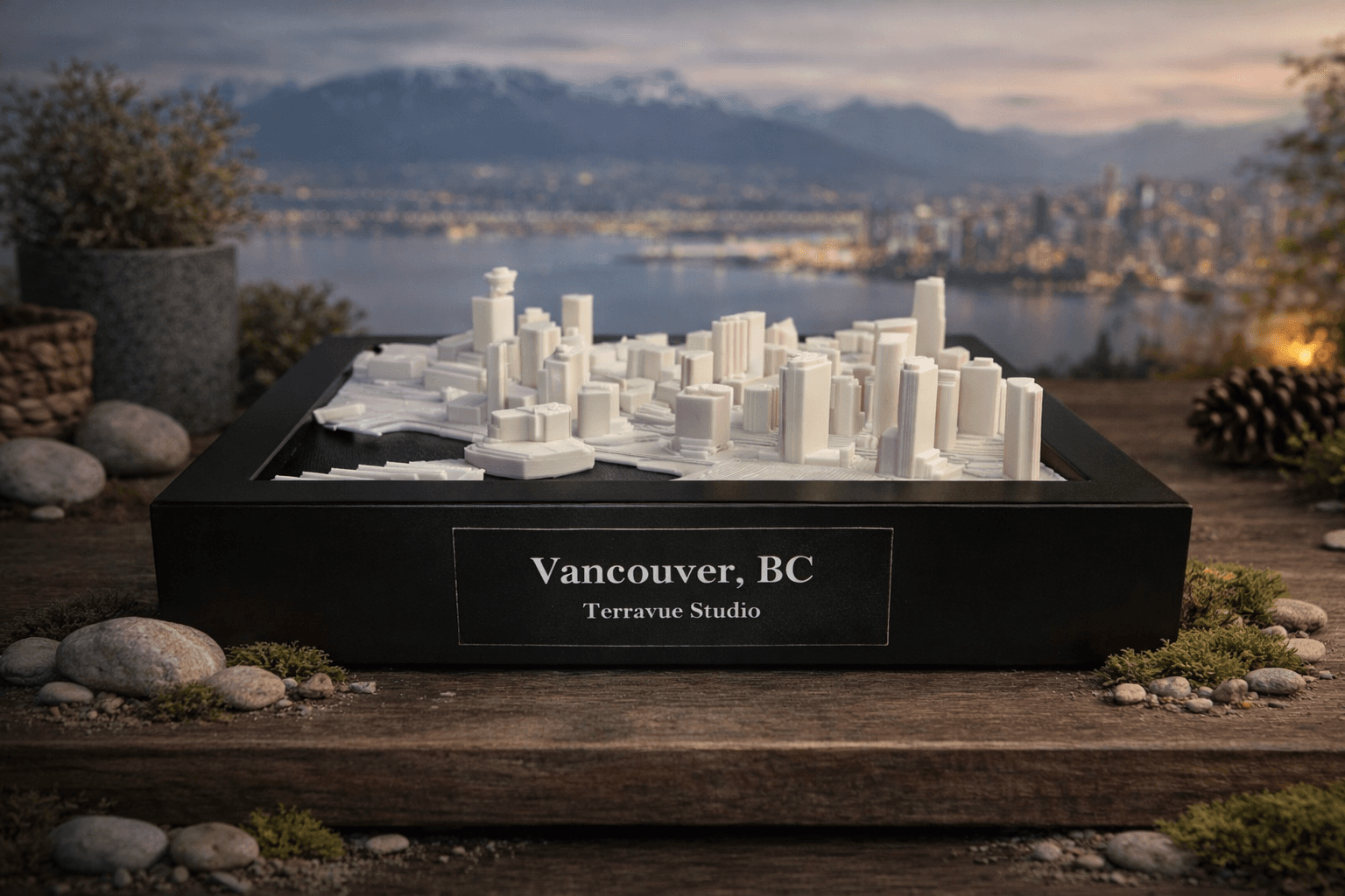
Vancouver's geography is unlike any other city. Nestled between the Pacific Ocean and the Coast Mountains, the city's layout follows natural contours while maintaining a modern urban grid. Our 3D map highlights this unique relationship between nature and city planning.
The map captures iconic features like Stanley Park's peninsula, the downtown peninsula with its distinctive skyline, and the elevation changes that make Vancouver's neighborhoods so visually distinct. The North Shore Mountains create a dramatic backdrop, while False Creek and English Bay add natural beauty to the urban landscape.
Whether you're a Vancouver native, a recent transplant, or someone who simply appreciates beautiful city design, this map serves as both functional art and a meaningful connection to one of the world's most livable cities.
What Makes This Vancouver Map Special
Why Vancouver Looks Stunning as 3D Wall Art
Vancouver's combination of dramatic mountains, ocean, and dense urban areas creates natural depth and visual interest. The elevation changes are particularly striking in 3D—you can literally feel the mountains rising behind the city.
The city's geography tells a story: how a modern metropolis adapted to work with, rather than against, its natural setting. This relationship between built and natural environments is beautifully captured in raised relief.
The map works especially well in minimalist interiors, where the clean lines of the city grid contrast with the organic forms of mountains and water. It's both architectural and natural—a perfect representation of Vancouver itself.
Key Features & Landmarks
Our Vancouver map highlights these distinctive features:
Vancouver Geography
Vancouver sits on the Pacific coast, surrounded by mountains to the north and ocean to the west. The city's layout follows natural contours, with downtown on a peninsula and neighborhoods spreading along the coastline and up the mountain slopes.
Perfect Gift For
Looking for more gift ideas? Check out our guide to 3D map gifts or explore personalized map options.
Materials + 3D Printing Process
Each Vancouver map is created using premium PLA filament, printed layer by layer with high precision. The terrain and city features are digitally sculpted from real geographic data, ensuring accuracy and detail.
After printing, every piece is hand-finished for smoothness and clarity, then mounted on a premium backing board. The final step is framing in a deep, modern gallery frame designed to last decades.
- ✓Premium 3D printed PLA material
- ✓Hand-finished for smoothness and detail
- ✓Premium backing board mounting
- ✓Deep-set gallery frame (black or walnut)
- ✓Ready-to-hang hardware included
Available Sizes & Options

Tabletop (13 × 18 × 3 cm)
Inner print: 10 × 15 cm with 1.5 cm frame on all sides. Available in Black only.
Perfect for desks, small walls, or as a gift. Starting at $99 USD.

Classic Wall (16 × 21 × 3 cm)
Inner print: 13 × 18 cm with 1.5 cm frame on all sides. Available in Black, Oak, or Walnut.
Our most popular size. Ideal for living rooms and offices. Starting at $199 USD.

Gallery Wall (23 × 28 × 3 cm)
Print in 20 × 25 cm border with 1.5 cm frame on all sides. Available in Black, Oak, or Walnut.
Large format with gold-accent badge and certificate. Starting at $299 USD.
Shipping Information
We ship worldwide from our Vancouver studio. Free shipping available for orders in Canada and the United States. International shipping available with fully insured delivery.
Production time: 5-7 business days from order confirmation. Your Vancouver map will be carefully packaged and shipped ready to hang.